Hadrian's High Way
A new 102 mile walk along Rome's northernmost frontier

Hadrian’s High Way is a 102 mile trail devised, written and illustrated by acclaimed outdoor writer Mark Richards. The trail takes a dynamic, new look at the northernmost frontier of the Roman Empire and embraces the majestic landscape through which the garrisons marched for 300 years.

Download file for GPS

Holiday Packages

All our Standard Itineraries include:

  • Hand-picked accommodation in B&Bs / guest houses / inns / small hotels
  • En-suite facilities where available
  • Breakfast
  • Daily baggage transfers from our own team of local drivers
  • All booking fees

We will also endeavour to include all these in any custom itinerary you wish to build for this walk.

Itin A:   9D / 10N       £1410 pp *

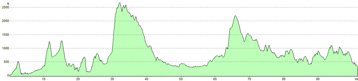
Day 1: Ravenglass to Boot (9m)
Day 2: Boot to Skelwith Bridge (11.6m)
Day 3: Skelwith Bridge to Troutbeck (6.8m)
Day 4: Troutbeck to Askham (15.6m)
Day 5: Askham to Temple Sowerby (10.9m)
Day 6: Temple Sowerby to Milburn (7.2m), taxi to Appleby*
Day 7: taxi to Milburn, walk to Alston (13.9m)
Day 8: Alston to Greenhead (15.1m)
Day 9: Greenhead to Bardon Mill (13.9m)

£1,410 per person (based on two sharing)

*price includes taxi

Get a Personal Quote

Itin B:   5D / 6N       £920 pp *

Day 1: Ravenglass to Skelwith Bridge (20.2m)
Day 2: Skelwith Bridge to Askham (22.4m)
Day 3: Askham to Milburn (17.1m), taxi to Appleby*
Day 4: taxi to Milburn, walk to Slaggyford (19m)
Day 5: Slaggyford to Bardon Mill (23.3m)

£920 per person (based on two sharing)

*price includes taxi

Get a Personal Quote

Itin C:   11D / 12N       £1640 pp *

Day 1: Ravenglass to Boot (8.2m)
Day 2: Boot to Little Langdale (11.2m)
Day 3: Little Langdale to Troutbeck (9.8m)
Day 4: Troutbeck to Askham (15.6m)
Day 5: Askham to Temple Sowerby (10.9m)
Day 6: Temple Sowerby to Milburn (7.2m), taxi to Appleby*
Day 7: taxi to Milburn, walk to Alston (13.9m)
Day 8: Alston to Slaggyford (5.7m)
Day 9: Slaggyford to Greenhead (9.3m)
Day 10: Greenhead to Once Brewed (7m)
Day 11: Once Brewed to Bardon Mill (7.9m)

£1,640 per person (based on two sharing)

*price includes taxi

Get a Personal Quote

* All headline holiday prices are shown per person, based on two people sharing.

** Prices may vary depending on availability, time of year, number of travellers and room type. Please enquire for a personalised quote. 

Walk Information

Rest Days
Rest days can be incorporated into any walking holiday package.

Solo Travellers
Solo travellers please contact us or use the booking form to send your proposed itinerary including dates, and we will price accordingly. Where possible, we take advantage of existing bookings from other clients to ensure you receive a cost effective service.

Alternative Itineraries
For alternative itineraries to those provided for this route, please contact us, or use the Booking Form to submit your proposed itinerary and number of participants and we will quote accordingly.

Walking Season Dates
Prices are based on the walk starting after 1st April and ending before 30th September.

Walk Information

Hadrian’s High Way is a 102 mile trail devised, written and illustrated by acclaimed outdoor writer Mark Richards.

The trail takes a dynamic, new look at the northernmost frontier of the Roman Empire and embraces the majestic landscape through which the garrisons marched for 300 years.

There is no better way to view fell country than to follow the Roman road east from the port at Ravenglass, the maritime link with the Roman Empire, passing through wild mountains to ultimately trace the frontier along the Great Whin Sill where the Wall sits proud upon a striking escarpment within Northumberland National Park.

This is a real journey of discovery, linking ten forts, each in turn vital connections underpinning life on the Wall.

The trail stretches for just over 100 miles through the constantly changing, thoroughly absorbing, and spellbindingly beautiful landscape of the Lake District, Cumbria and Northumberland

OS Explorer Maps
OL5 – English Lakes – North-eastern area
OL6 – English Lakes – South-western area
OL7 – English Lakes – South-eastern area
OL31 – North Pennines
OL43 – Hadrian’s Wall

Guide Books
Hadrian’s High Way” by Mark Richards

Mobile Digital Mapping
Digital maps can be viewed on most modern smartphones using an appropriate app, downloaded from the app store associated with your device. Brigantes recommend that whichever app you use, it should support Ordnance Survey 1:25k or 1:50k scale maps. There are many apps to choose from, but the two main providers are Ordnance Survey and Memory Map.

Each provider’s app has its own benefits, but both provide all-important offline navigation, meaning your device does not need a mobile signal to work effectively on the trail.

Walks you may also like...

Wainwright's Way

Wainwright's Way

Wainwright's Way is a 123 mile walk from the birthplace of the famous author, across the hills he loved to his final resting place
Click Here

Bronte Way

Bronte Way

The Bronte Way is a 43 mile cross-Pennine route linking locations associated with the lives and works of the Bronte sisters
Click Here

St. Bega's Way

St. Bega's Way

The 36 mile St. Bega's Way links St Bega's church in St Bees, to the church of the same name by the shores of Bassenthwaite Lake
Click Here
Search

Walkers' Testimonials

Have you walked this route? Please leave a review and let others know what you think.

Use the comments form below to submit your testimonial for this walk. Rest assured, we won’t display or disclose your email address! It is only required to prevent spam – and to enable you to receive notifications of any responses to your review should you select the option to do so.

2 Replies to “Hadrian’s High Way”

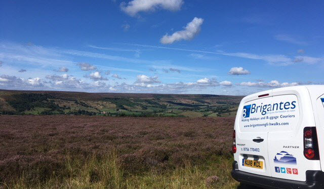
  1. We enjoyed walking Hadrians Highway very much, not only the variety in landscape (meadows, fells, riverbanks, villages, lakes) but also the many roman traces we saw along the way, the castles and other curiosities . We visited Lowther Castle and Vindolanda which were both stunning.
    Even before travelling we were very pleased with the organisation by Brigantes: every question we had was answered very quickly, In organizing accomodation and transport Brigantes was fast and flexible with excellent communication.
    The places we stayed were all cosy and comfortable, all with their own character. We were always welcomed warmly, breakfast was fine.
    We hat a wonderful time walking Hadrians Highway, thanks Brigantes!

    Andrea and Klaas
    The Netherlands

  2. Really enjoyed our walk along Hadrian’s Wall and the excellent planning by Brigantes – brilliant selection of places to stay along the way and the logistics of bags moving every day worked like a dream. Thank you so much!

Leave a Reply

Your email address will not be published. Required fields are marked *

This site uses Akismet to reduce spam. Learn how your comment data is processed.