Rest Days
Rest days can be incorporated into any walking holiday package.
Solo Travellers
Solo travellers please contact us or use the booking form to send your proposed itinerary including dates, and we will price accordingly. Where possible, we take advantage of existing bookings from other clients to ensure you receive a cost effective service.
Alternative Itineraries
For alternative itineraries to those provided for this route, please contact us, or use the Booking Form to submit your proposed itinerary and number of participants and we will quote accordingly.
Walking Season Dates
Prices are based on the walk starting after 1st April and ending before 30th September.
Walk Information
The popularity of this walk with our seasoned clients resulted in a desire to develop the format from the first rudimentary sheets and laminated day maps as soon as time permitted.
Sadly, this had to wait for time and circumstances, which materialised when my friend, Stuart Greig, recognising the special individuality of the walk took the time for research and exploration to produce an excellent pocket book and guide.
Brigantes has serviced walks all over the north of England for over 20 years. We know from experience and the various website chat forums, that many people complete one after another of these walks, slogging from stop-over to stop-over, appreciating the beautiful countryside through which they have passed, happy and tired with another notch cut on their sticks. They have seen the hills, the moors, the dales and the valleys, and crossed the rivers, but 24 hours later, are quite likely to be unable to put names to many of them, and by maintaining their imposed daily targets of distance and time, they tend to have missed a lot of the interesting features available in the areas through which they have passed. Apart from experiencing the ever-changing scenery, the result of completing the most recent walk is broadly similar to the completion of any previous walks.
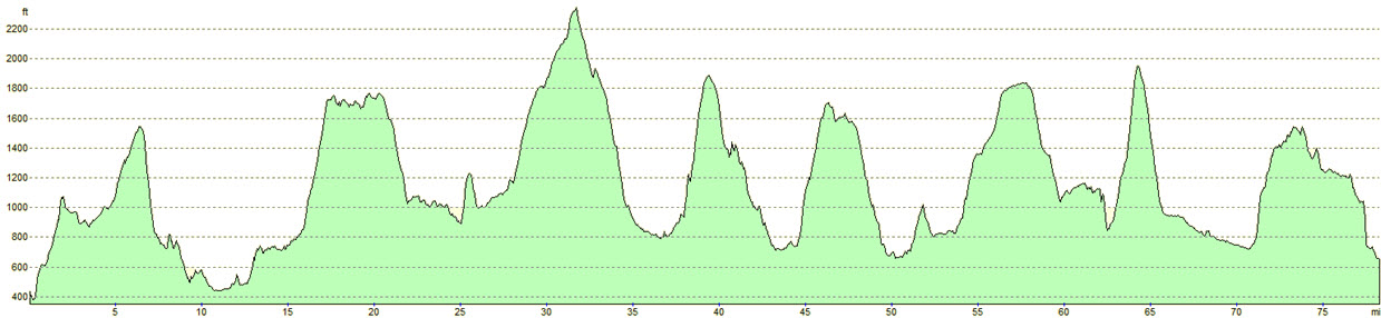
With this in mind, I decided to create my own walk around the tributaries of some of the Yorkshire Dales rivers (the Tributaries Walk) making this a circular tour for the ease of arrival and departure, and which would hopefully address some of the shortcomings of existing routes. It would take in what I consider to be some of the finest and most spectacular high-level scenery in England, whilst providing the opportunity for the walker to stop and stare, to become proficient in the use of GPS through navigational exercises, the naming and recording of the rivers and their tributaries, and to observe geological and geographical landmarks and other points of interest, which would ordinarily have been passed by.
Having completed the walk, an evening meal and a bottle of wine are the rewards for the successful completion of a navigational puzzle involving map references and the GPS used during the walk.
I am grateful for Stuart Greig’s input into the project by producing this guide book.
OS Explorer Maps
OL2 – Yorkshire Dales – Southern & Western areas
OL30 – Yorkshire Dales – Northern & Central areas
Guide Books
“The Tributaries Walk” by Stuart W. Greig – Published by Pocket Routes
Mobile Digital Mapping
Digital maps can be viewed on most modern smartphones using an appropriate app, downloaded from the app store associated with your device. Brigantes recommend that whichever app you use, it should support Ordnance Survey 1:25k or 1:50k scale maps. There are many apps to choose from, but the two main providers are Ordnance Survey and Memory Map.
Each provider’s app has its own benefits, but both provide all-important offline navigation, meaning your device does not need a mobile signal to work effectively on the trail.