Holiday Packages
All our Standard Itineraries include:
- Hand-picked accommodation in B&Bs / guest houses / inns / small hotels
- En-suite facilities where available
- Breakfast
- Daily baggage transfers from our own team of local drivers
- All booking fees
We will also endeavour to include all these in any custom itinerary you wish to build for this walk.
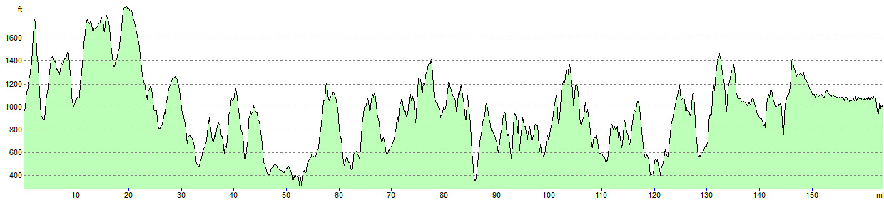
This route follows the eastern section of the Mary Townley Loop, the western section of the Settle Loop & western Selside Loop
Day 1: Middleton Top to Parsley Hay (11.4m), taxi to Youlgreave*
Day 2: Taxi to Parsley Hay, walk to Wormhill (8.3m) taxi to Tideswell*
Day 3: taxi to Wormhill, walk to Hayfield (14m)
Day 4: Hayfield to Padfield (11.6m)
Day 5: Padfield to Diggle (12.1m)
Day 6: Diggle to Hollingworth Lake (11.2m)
Day 7: Hollingworth Lake to Hebden Bridge (14.8m)
Day 8: Hebden Bridge to Thursden (13.9m), taxi to Burnley*
Day 9: taxi to Thursden, walk to Kelbrook (11.2m)
Day 10: Kelbrook to Gisburn (11m)
Day 11: Gisburn to Settle (12.3m)
Day 12: Settle to Clapham (11.5m)
Day 13: Clapham to Whinshaw (11.3m)
Day 14: Whinshaw to Garsdale Head (13.9m)
Day 15: Garsdale Head to Crossbank/end of the route (10.7m)
£2,180 per person (based on two sharing)
*price includes taxis
Primarily designed for cyclists, this route follows the western section of the Mary Townley Loop, the eastern section of the Settle Loop & eastern Selside Loop
Day 1: Middleton Top to Glossop (45.8m)
Day 2: Glossop to Hebden Bridge (39.3m)
Day 3: Hebden Bridge to Settle (56.6m)
Day 4: Settle to Crossbank/end of the route (43.4m)
£770 per person (based on two sharing)
Primarily designed for cyclists, this itinerary follows the eastern section of the Mary Townley Loop, the eastern section of the Settle Loop & eastern Selside Loop
Day 1: Middleton Top to Hayfield (35.8m)
Day 2: Hayfield to Hollingworth Lake (33.3m)
Day 3: Hollingworth Lake to Kelbrook (36.9m)
Day 4: Kelbrook to Clapham (33.8m)
Day 5: Clapham to Crossbank/end of the route (32.9m)
£890 per person (based on two sharing)
Primarily designed for cyclists, this itinerary follows the eastern section of the Mary Townley Loop, the eastern section of the Settle Loop & eastern Selside Loop
Day 1: Middleton Top to Hayfield (35.8m)
Day 2: Hayfield to Diggle (22.1m)
Day 3: Diggle to Hebden Bridge (24.6m)
Day 4: Hebden Bridge to Kelbrook (25.1m)
Day 5: Kelbrook to Austwick (30.7m)
Day 6: Austwick to Crossbank/end of the route (34.5m)
£1,020 per person (based on two sharing)
Primarily designed for cyclists, this itinerary follows the eastern section of the Mary Townley Loop, the eastern section of the Settle Loop & eastern Selside Loop
Day 1: Middleton Top to Monyash (15.1m)
Day 2: Monyash to Hayfield (23.9m)
Day 3: Hayfield to Diggle (22.1m)
Day 4: Diggle to Hebden Bridge (24.6m)
Day 5: Hebden Bridge to Kelbrook (25.1m)
Day 6: Kelbrook to Settle (22.3m)
Day 7: Settle to Whinshaw (21.8m)
Day 8: Whinshaw to Crossbank/end of the route (24.6m)
£1,240 per person (based on two sharing)
Primarily designed for cyclists, this itinerary follows the eastern section of the Mary Townley Loop, the eastern section of the Settle Loop & eastern Selside Loop
Day 1: Middleton Top to Wormhill (21.8m), taxi to Tideswell*
Day 2: taxi to Wormhill, walk to Hayfield (14m)
Day 3: Hayfield to Padfield (11.6m)
Day 4: Padfield to Diggle (12.1m)
Day 5: Diggle to Hollingworth Lake (11.2m)
Day 6: Hollingworth Lake to Hebden Bridge (14.8m)
Day 7: Hebden Bridge to Laneshawbridge (21.2m)
Day 8: Laneshawbridge to Gisburn (15.5m)
Day 9: Gisburn to Austwick (21.7m)
Day 10: Austwick to Whinshaw (13m)
Day 11: Whinshaw to Garsdale Head (13.9m)
Day 12: Garsdale Head to Crossbank/end of the route (10.7m)
£1,840 per person (based on two sharing)
*price includes taxi
This itinerary follows the eastern section of the Mary Townley Loop, the eastern section of the Settle Loop & eastern Selside Loop
Day 1: Middleton Top to Friden (9m), taxi to Hartington
Day 2: Taxi to Friden, walk to Monyash (6.1m)
Day 3: walk to Wormhill (9.9m), taxi to Tideswell
Day 4: taxi to Wormhill, walk to Rushop Hall (7.2m), taxi to Castleton*
Day 5: taxi to Rushop Hall, walk to Hayfield (6.8m)
Day 6: Hayfield to Padfield (11.6m)
Day 7: Padfield to Diggle (12.1m)
Day 8: Diggle to Hollingworth Lake (11.2m)
Day 9: Hollingworth Lake to Mankinholes (10.7m)
Day 10: Manikinholes to Hebden Bridge (4.8m)
Day 11: Hebden Bridge to Thursden (13.9m), taxi to Burnley*
Day 12: taxi to Thursden, walk to Kelbrook (11.2m)
Day 13: Kelbrook to Gisburn (11m)
Day 14: Gisburn to Long Preston (8.5m) taxi to Settle*
Day 15: Taxi to Long Preston, walk to Settle (3.8m)
Day 16: Settle to Clapham (4m)
Day 17: Clapham to Whinshaw (11.3m)
Day 18: Whinshaw to Garsdale Head (13.9m)
Day 19: Garsdale Head to Crossbank/end of the route (10.7m)
£2,840 per person (based on two sharing)
*price includes taxis
* All headline holiday prices are shown per person, based on two people sharing.
** Prices may vary depending on availability, time of year, number of travellers and room type. Please enquire for a personalised quote.
Baggage Transfer
Baggage Transfer is automatically included in the price of all our Walking Holiday packages.
These prices are for anyone planning their own holiday and just need bags moving from one stop to the next.
Please enquire for availability
Note: If you are booking accommodation in an Airbnb, you must ensure that there will either be someone available to take collection/delivery of your bags or that they have appropriate, secure storage in the event that the proprietor is absent.
One Reply to “Pennine Bridleway”
I walked the linear route of the Pennine Bridleway over 15 days with Brigantes and I have to say that the organisation was exceptional. I stayed in a mixture of bed and breakfasts and inns, all of which catered well for walkers. These were also within easy walking distance from the path, or if not, Brigantes had organised a taxi collection service, returning to the path the next morning.
Despite this being called the Pennine Bridleway, I saw no horse riders, few walkers and just a few cyclists. If you’re after a quiet and peaceful walk through lovely countryside then I would thoroughly recommend this walk.