Rest Days
Rest days can be incorporated into any walking holiday package.
Solo Travellers
Solo travellers please contact us or use the booking form to send your proposed itinerary including dates, and we will price accordingly. Where possible, we take advantage of existing bookings from other clients to ensure you receive a cost effective service.
Alternative Itineraries
For alternative itineraries to those provided for this route, please contact us, or use the Booking Form to submit your proposed itinerary and number of participants and we will quote accordingly.
Walking Season Dates
Prices are based on the walk starting after 1st April and ending before 30th September.
Walk Information
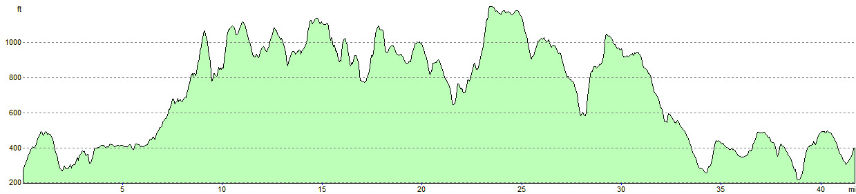
The Bronte Way is a 43 mile long distance footpath which starts at Oakwell Hall (“Fieldhead” in Charlotte Bronte’s novel “Shirley”) near Birstall in Kirklees near Bradford, and ends at Gawthorpe Hall in Padiham near Burnley. A challenging walk which has moorland scenery, heritage and literary aspects.
The route winds past many places of interest to Bronte enthusiasts, including the Bronte Birthplace in Thornton, Ponden Hall (“Thrushcross Grange” in Emily Bronte’s novel “Wuthering Heights”), Wycoller, and of course, the village of Haworth itself. Scenic highlights include Penistone Hill country park, perched on the moors high above Haworth, the trail to the Bronte Waterfall and on over the Bronte Bridge up to Top Withens (a favourite walk of the Brontes themselves – Top Withens being suggested as the contentious setting for the Earnshaw farmstead in “Wuthering Heights”), and Wycoller in the Forest of Trawden at the edge of Pendle Witch Country.
While some of the Bronte Way crosses wild and desolate moorland, civilisation is never far away and there are plenty of pubs and country houses to stop off for a quick pint of ale en-route.
Places which can be visited along the route include Oakwell Hall (starting point) in Kirklees, Clayton village, Thornton village (including the Bronte Birthplace), Haworth village (including the Bronte Parsonage), The Bronte Waterfall, The Bronte Chair, The Bronte Bridge, Ponden Hall, Top Withens, Wycoller, Gawthorpe Hall (finishing point) near Burnley.
The route is waymarked with a yellow arrow on a magenta background for much of the way, although some can be easily missed. In places the route is coincident with other long distance paths whose waymarking takes precedence, so some care is required. Having the guidebook and OS Explorer maps is recommended to ensure reliable route finding, particularly on the moorland sections.
OS Explorer Maps
OL21 – South Pennines
Guide Books
“The Bronte Way” by Paul Hannon
“The Bronte Way” by Marie Wilson
Mobile Digital Mapping
Digital maps can be viewed on most modern smartphones using an appropriate app, downloaded from the app store associated with your device. Brigantes recommend that whichever app you use, it should support Ordnance Survey 1:25k or 1:50k scale maps. There are many apps to choose from, but the two main providers are Ordnance Survey and Memory Map.
Each provider’s app has its own benefits, but both provide all-important offline navigation, meaning your device does not need a mobile signal to work effectively on the trail.
One Reply to “Bronte Way”
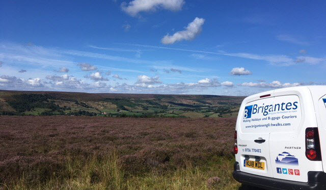
My party used Brigantes once again, this time for the Bronte Way. Once again they were easy to deal with and collected and delivered our bags safely and efficiently.